Land Reclamation Around Thorney Island
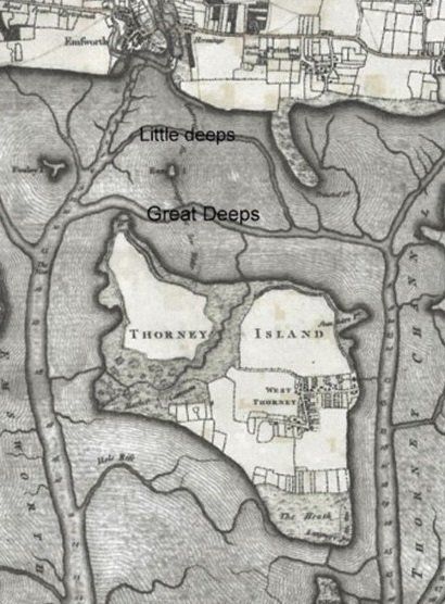
Thorney Island is now a misnomer as our modern maps show it a peninsular, much like Chidham. However, the location of The Deeps, a string of deep lagoons running east west between the shores gives a clue to the history of the changes in the Harbour.
The 1780’s Ordnance Survey map shows high tide coming up to where the Thornham Sewerage farm is now. A wide channel between there and Thorney Island was crossed by a wash-way as the only foot access on to the Island. This causeway was covered for most of the tide. An extract of the County Gazette displayed in our Choir tells of the Bishop visiting a bucolic scene on Thorney Island.


Sometime around 1850, an act of Parliament was made to reclaim land in Emsworth Harbour and Thorney Marshes. With the increase in farming output, the old wash-way to Thorney Island had been problematic for carriers, as it a restricted access due to tides. A drowning of a child on a journey to school in Emsworth was doubtless, yet another driver to join Thorney island to the mainland.
Reclamation was proposed in three tranches, west to east:
• from Wickor Point on the west of Thorney to Hayling Island;
• from Thornham to join the Island to the mainland and;
• from Pilsea Island to Cobnor Point on the Chidham peninsular.
This reclamation was a commercial venture suggested by an 1882 auction notice for the sale of the new land.
In the event, only the joining of Thorney Island to the mainland was successful. This was achieved by building two revetments: one on the Wickor side (west) and; the other on the Thorney side (east) to join Thorney Island to the mainland. Construction was completed on Monday 5th September 1870. This area comprises Lot 1 in the 1882 auction notice.
Following the completion of the banks, the water was left to drain away, leaving just the Great and Little Deeps more or less as they are today in ridges of alluvium sediment. Three outlets were installed, one under each revetment and one under the old causeway close to the Army gate house.
The joining to the mainland led (in part) to the demise of Nutbourne Mill. At the time the Mill relied on grain deliveries being made by barges from Dell Quay and the delivery of flour to supply Portsmouth victualing yard via The Deeps, Northam Channel and Eastney Lock. The reclamation between Pilsey Island and Cobnor Point would have led to the Mill being cut off and therefore not able to get the grain delivery. In any case, a few years later the mill burnt down.
While the Cobnor-Pilsea was attempted, this lasted approximately 6 months, until eventually the tide broke through, leaving it pretty much as it is today. The 1882 auction notice has this reclaimed land as Lot2.
The section in Emsworth harbour would have disrupted the Oyster trade, so was probably a non-starter.
Today, sailors in the Thorney and Chichester Channels pass the remains of these efforts seen as the remains of the shingle bank, clearly shown on the harbour chart. From the Cobnor Point end, you can get a good view of what was intended as it is closer to the shore.
Next time you walk down from Prinsted, past the boatyards on the lane, look to the west for an idea of how deep the water was before the sea walls were put in. Timing your walk along the coast path with a high spring tide, you will see just how the revetments hold back high water as man’s ingenuity has adapted the landscape in spite of sea level rise. These efforts established and sustains The Deeps and its marshes as a unique habitat for us to enjoy today.
Adapted from notes by David Holeman 2021


